
Our Gullies and Waterways
Tamahere’s streams, gullies and river margins form important wildlife corridors — but they also provide routes for rats, possums and mustelids. They are also part of a landscape of longstanding cultural significance to mana whenua.
We are building a clearer picture of how these gullies and waterways connect, how they have been known locally, and which neighbourhoods sit within each catchment. This page is a work in progress, and local knowledge is welcome.
Most gully systems are on private land. Public access is limited to established walkways such as Tamahere Reserve, Allan Turner Bridge and Bilsthorpe. The areas shown below are approximate and do not indicate public access to gullies, waterways or adjoining land.
Tamahere Mangaone Restoration Trust (TMRT) leads ecological restoration and walkway development on local public gully land. Predator Free Tamahere complements this by supporting predator control across both public and private habitat.
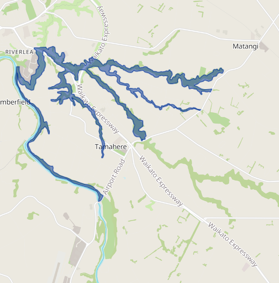
Council-mapped Tamahere gullies and wetlands
This Waikato District Council map shows some of the main Tamahere gullies and wetlands identified for protection and restoration. It does not include every waterway, including parts of the Mangaonua and the Tamahere Drive gully, so use it together with the local descriptions below. Click the map to explore the original interactive version.
-
One of Tamahere’s largest and most branched gully systems. It connects with the Mangaharakeke and Mangaonua before reaching the Waikato River.
Nearby roads include: Bruntwood, Woodcock, Rosebanks, Bollard, Sanctuary, Cherry, Seabrook, Cedar Park, Annebrook, Mangaone Lane, Hillbrook Way and Green Haven Lane.
Current focus: Filling gaps in existing trap coverage.
-
Several substantial northern gullies connect with the Mangaone system.
Nearby roads include: Kendrick Lane, Newell, Hart, Pekapeka Lane, Birchwood Lane, Platinum Place, Vintners Lane, Townshend Lane, Camdon Place, Koppens Road and Devine Road.
Current focus: Filling gaps in existing trap coverage.
-
A separate southern branch of the Mangaone Stream
Nearby roads include: Oaklea Lane, Mangaomapu Lane, Fernando Drive, Bruntwood and Pickering.
Current focus: Filling gaps in existing trap coverage.
-
A significant corridor containing established bush, regenerating vegetation and restoration planting.
Nearby roads include: Tauwhare, Titoki, Alisha Place, Cranmere, Woodcock, Windmill, Bilsthorpe Lane and Fuchsia Lane.
Current focus: Predator control to protect the restoration plantings around Windmill Road and Bilsthorpe Lane.
-
This gully system is often labelled the Rosebanks Drive gully in Council records.
Nearby roads include: Kew Place, Greenvale Close, Woodcock, Hodge, Acacia Grove, Rosebanks and Windmill.
Current focus: Filling gaps in existing trap coverage.
-
This larger waterway follows Tamahere’s northern boundary and continues well beyond the PFT project area.
Nearby roads include: Poplar Lane, Matangi, Meadowgreen, Newell and Riverglade.
Current focus: Neighbourhood predator control through the Poplar Lane project.
-
The large gully beside the Waikato Expressway and opposite Tamahere Country Club may be Waiti Stream. We have not yet confirmed whether this name applies to the whole gully system.
Nearby roads include: Tamahere Drive and Day Road.
Current focus: Filling gaps in existing trap coverage.
-
The river boundary includes several smaller gullies, wetlands and river-edge habitats.
Nearby roads include: Pencarrow, Te Awa, Te Awa Lane, Blue Heron Place, Airport, Narrows Lane, Riverfields Lane, Twin Oaks Drive, Redwood Grove, Newell and Riverglade.
Current focus: Filling gaps in existing trap coverage.
Which gully are you connected to?
Especially if you live beside a gully or the Waikato River, your property may form part of a wider predator-control corridor.
Already trapping? Tell us what you are doing
Know a local stream or gully name?
Official maps do not always record local or historic names. We would especially like information about the northern Mangaone tributaries and the possible Waiti Stream catchment.